
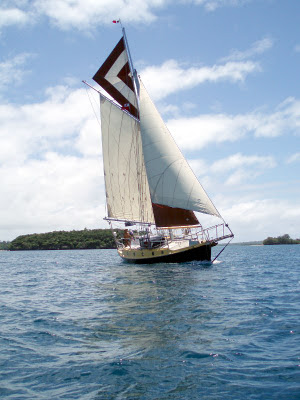

During the year that Iron Bark had spent in Australia,Trevor and I had covered many thousands of miles while our little ship had been much less active than usual, staying securely anchored in Queensland’s Burrum River (between Maryborough and Bundaberg).
Trevor had done a lot of work on the inside of the boat, chipping and painting areas of corrosion: three winters frozen into ice had resulted in massive amounts of condensation come spring, which had taken its toll. Iron Bark was now in good shape once more and looking forward to new adventures. On 22 December 2008, we said good-bye to friends in Bundaberg and turned our bows towards the sea.
With little wind, we motored to cheat the tide; the necessity to clear Customs had dictated our time of departure. Then, in a narrow part of the river, the engine started to overheat, so we ran back to where there was room to anchor and tried to see what the problem was. This took a couple of hours, at the end of which we were little the wiser and indeed, the engine continued to overheat in an unpredictable fashion for several more months. By now the sea breeze had filled in with a vengeance and the flood was running hard. We had a long, slow and rough motor out of the river and I was feeling distinctly seasick when we finally killed the engine and started to beat offshore under reefed main, jib and staysail. It seemed an inauspicious start to our passage back across the Tasman.

 The next day saw us continuing to beat against a gradually decreasing wind. By 1920 we were enjoying a lovely, quiet evening and I had put up the Christmas decorations. The wind continued light during Christmas Eve, but for once we had a fair current which pushed us on our way, while I put up the Christmas decorations. The afternoon was spent wrapping up presents, which were tastefully arranged in a laundry basket on the chart table, and there they stayed in the prevailing quiet conditions.
It was our second Christmas at sea in 2 years. At midnight we were ‛blasting along at 6/7 knots and making excellent progress’, but the wind took off for us to have a very pleasant day, opening presents and eating and drinking in true Yuletide fashion.
For the next week we enjoyed fair winds and a kindly current. There was often enough breeze to justify both reefs in the main, but progress was comfortable. We sailed within sight of Elizabeth Reef, which in these days of GPS was merely an interesting event; the well-known self-steering designer, John Letcher, lost a boat here and we were both less than relaxed until we knew for sure that we had seen it – GPS notwithstanding.
A vicious squall on New Year’s Eve gave Trevor a hard time: although the mainsail came down without any problems, he had a tussle getting sail tiers round the bundle. After years of debating the merits and otherwise of lazyjacks, I believe it was this night that finally made up his mind to fit them.
The New Year came in quietly and we sighted our first Wandering Albatross. The weather was getting distinctly cooler and it was pleasant to feel the need for a cover on the bed.
Apart from a couple of days spent close-hauled, we enjoyed fair winds all the way to South Island. On Wednesday 7 January, Trevor sighted Taranaki’s perfect cone at dawn. We raced along all day and arrived off Farewell Spit, at the entrance to Tasman Bay, just after midnight. Predictably, the wind then switched off and we drifted until the sea breeze filled in, enjoying the views of snow-clad mountains.
At 1600, we entered Nelson Harbour and started the motor, furling the sails as we motored up to the Customs Dock. We had taken 17½ days to cover 1540 miles.
We spent a pleasant three weeks in Nelson, catching up with friends before heading off once more. Our intention was to go and have a look at Fiordland, which Trevor had already cruised about 20 years previously, and then to have explore Stewart Island – a pleasant way of spending the summer months. We spent a day or so anchored off beautiful Adele Island (40°58.7’S, 173°03.3’E) before leaving. It’s about 450 miles from Nelson to Milford Sound and once you leave Tasman Bay, you may as well go straight there because the only harbours along the way are impassable in anything other than perfect weather. We had a fine forecast of NE winds, but they failed to materialise until we were within 6 miles of our intended anchorage. In the meantime we had a mixed bag of winds and more beating than we would have chosen. With an imminent gale forecast, we pushed on as hard as we could, but in the end resorted to motoring rather than finding ourselves jammed up against that iron-bound coast.

We arrived off Milford Sound in suitably dramatic conditions: Scotch mist eddying with the gusts of wind and the mountains’ feet emerging from the murk as we closed the coast. Much has been written about the scenery of Milford and many photos taken, but even so I was impressed with what we saw. It is on the grandest scale and even although I am by now something of a connoisseur of majestic scenery, I found it magnificent. But we were far from being alone in our pleasure: as we made our way along the Sound, we were accompanied by 2 vast cruise ships, four tour boats, several helicopters and a couple of ’planes to say nothing of half a dozen runabouts.
We brought to in Deepwater Basin (44°40.9’S, 167°55.7’E) at 1830, took a stern line ashore and sat down to admire the scenery of rugged peaks and a snowfield, with lush rain forest dotted with enormous tree ferns on the lower slopes.

Tired after our passage, we would have slept in, but were driven from our comfortable berth by very unwelcome visitors. The sandflies, for which Southland is notorious, commenced their attack at daybreak and continued, unremittingly until dark. The only time they let up was when the wind was too strong for them to fly. Iron Bark has screens, which have successfully foiled Tropical insects, Labrador blackfly, Greenland mosquitoes and Tasmanian horseflies, but they hardly slowed down the sandflies. If you looked carefully, you could see them working their way through the mesh one careful leg at a time. Then they homed in. Even mosquito coils had little deterrent effect. The only consolation was that the climate was such that one was rarely tempted to strip off. Liberal use of insect repellent kept them from one’s hands and face, but they were an infernal nuisance, and even Trevor, who generally mocks my misery when mosquitoes bite, found them intolerable.
We woke to the sound of rain and it threw it down all day. A sheer cliff forms one side of Deepwater Basin and the rain poured down its face. As the day progressed and the volume of water increased, the whole cliff face became a myriad of spectacular waterfalls, with the surrounding mountains similarly transformed. It was an amazing spectacle. The dinghy needed regular baling and we filled our water tanks to overflowing with wonderfully pure water.
The clouds cleared away in the morning and the waterfalls dried up so quickly that most had vanished by mid-morning. I have never seen a landscape undergo such rapid transformation.

We duly did the tourist thing at the Interpretation Centre and went to the appropriate spot to admire and photograph Mitre Peak, which, if photographs involved friction, would surely have been ground down to a pimple by now. Then we went for a leisurely amble along the Cleddau river, sitting by the rushing waters to enjoy a picnic and gaze at the splendid scenery, even more stunning against a blue sky, which set off the snow to advantage.
We left in a flat calm that had the mountains reflected to perfection. Stopping only to watch some fur seals at play, we motored nearly all the way to George Sound. As is so often the case in Fiord country, we found the winds to be all or nothing – and, of course, funnelling along the fiords, several of which run perpendicular to the coast. In fine weather, they would invariably have a very fresh sea breeze blowing into them after about 1100. It paid to make an early start if moving on.

George Sound has several anchorages and we spent a few days pottering about. On one occasion we were accompanied by a pod of bottlenose dolphins which included two babies; they accompanied us for over an hour as we drifted and motored down the Sound, only leaving us when we dropped the hook off Alice Falls (44°58.7’S, 167°26.4’E)

Fiordland is infamous for its rain, but initially we enjoyed the most marvellous weather, although this meant rather too much motoring. Once we’d left Milford behind, we generally had the place to ourselves and when we did meet the occasional boat, it was an excuse for pleasant socialising rather than the all-too-common feeling of ‛Oh no!’. Surely one of the best aspects of sailing the higher latitudes is the empty anchorages.

We found another particularly pleasant anchorage in an unnamed cove at the head of Dagg Sound (45°26.0’S,166°54.2’E) in about 16 m, with plenty of swinging room. Coming in we had passed three of the rare Fiordland Crested Penguins, and finding this pretty spot seemed like the icing on the cake. Weka were calling to one another as we rowed ashore and we had a delightful little tramp across to Crooked Arm on Doubtful Sound, which gave us a wonderful view along its length.
When we came back to the beach, we went looking for a track that we’d read about in our guide. This would take us to Breaksea Sound and our intention was to locate its start and then tramp it the following day. We were very much looking forward to this, but in spite of our best efforts we could find only a few markers remaining. With a decent topo map we might have been able to follow the route, but we didn’t have one and anyway, I dislike bush bashing. It was a great disappointment: the Dept of Conservation preserve and maintain a vast number of tracks, which occasionally are abandoned for various reasons. They often remain quite usable for several years after, but in this instance, the forest had grown back very quickly. As we walked back along the pebble beach, one rolled from under my foot, badly twisting my left ankle. The pain was severe and I had to hobble to a nearby rock and wait for Trevor to go and fetch the dinghy and row back for me.
Back on board, I carefully removed my boot and gently massaged Arnica cream into my ankle, telling myself that it was only a twist. In fact it was a fairly severe sprain and was giving me the occasional twinge over 6 months later.
Bad forecasts kept us in harbour for the next couple of days, but although it blew hard, we were in good shelter and didn’t budge.
We got away again on the 22nd February and sailed/motored round to Dusky Sound. Another pretty anchorage was found in Second Cove (45°33.0’S, 166°48.5’E) alive with sandflies, which sent us below. But the following morning came in with a lovely sailing breeze and nary a sandfly to be seen. We left our anchorage and ran joyfully back up Breaksea Sound, but lost the breeze when we turned into Acheron Sound. We turned up Wet Jacket Arm and worked our way into a tiny anchorage between a small island and the shore (45°39.65’S, 166°44.12’E). Trevor had anchored here about 20 years previously, when he cruised the Fiords in his 30 ft Salvation Jane. We dropped the hook on some unpromising-looking rock and I held her in place with the engine while Trevor rapidly took lines ashore, bow and stern. The log notes it as being an ‛extremely compact little harbour’. It is variously known as Stick Cove and Muscle Cove, the latter being possibly the original spelling of Mussel, named by an exploring party from HMS Acheron, who dined well here. The wind increased during the day and the trees on the island in front of us swayed in the gusts, but only the odd eddy disturbed us.

 Astern of us was a beautifully wooded cliff and I admired – and photographed it – as I drank my morning cup of tea. We extricated ourselves without too many difficulties and then had the most delightful sail I can remember having in a long time. The wind was perfect, it was warm and sunny, the conditions were ideal for Iron Bark to make to windward and the pilotage was sufficiently intricate to be interesting. We anchored in Fanny Bay (45° 46.2’E 166° 51.5’S) in 30 m, ended up too close to shore so tried again in 20 m.
We ran a stern line ashore and went for a row round the bay and up a little stream that ran into it. Back on board, Trevor decided he wasn’t happy with our situation, and as there was plenty of daylight left we went to find another berth for the night. There is no shortage of places to choose in Dusky Sound, which I thought contained not only some of our nicest anchorages, but also the best sailing and we thoroughly enjoyed our sail through Nine Fathom Passage – named not for its shallowest spot, but for its narrowest point! A splendid little waterfall fell down the cliff, and the evening sun created lovely rainbows in it. We eventually anchored in 17 m in Shark Cove (45°43’S, 166°58.7’E).


 Back on board, we motored round to Cooper Island, where we spent the best part of an hour sorting out a complicated, but secure-looking mooring system. We went down below to get ourselves a well-earned drink and to listen to the forecast, only to hear the warning of an E gale – the only direction to which the anchorage was open. We disentangled ourselves, hauled the dinghy on board and Trevor sailed back to Shark Bay while I cooked our tea. We started the engine to investigate a better berth and dropped the hook behind a sand spit in relatively shallow water. Trevor then rowed a long line ashore, tying it round a huge fallen tree. I pulled in the slack and we sat down to our belated meal, feeling well-secured against whatever was heading our way.
As so often happens, the following day was apparently calm – tucked so far inside the Fiord system it wasn’t always easy to know what was going on. Another yacht sailed in – a rare event – and later Peter and Margret came over. They were interesting people, both master mariners, and told us that they were also sheltering from the ‛gale’ and were pleased that nothing seemed to be happening. They too, suspected the bottom of being rock. Later Navigator left for Supper Cove.
We spent a pleasant, sunny day at anchor. I bottled beer and started a new batch (lager: it brews well in cool conditions as long as you use the correct yeast), made savoury muffins for lunch, mixed muesli and finally cooked a delicious blue cod that Trevor had caught.
Dusky Sound, of course is redolent of Cook’s explorations, and for me it was imperative that we anchor in Pickersgill Cove where the Endeavour spent a peaceful and productive month. We had a gentle motor and drift there, somewhat marred by the gear connection at the engine shearing. Fortunately, there was little tide and what breeze there was enabled me to keep the boat out of trouble while Trevor did a temporary fix. It meant that we had to have an ‛engineer’ below putting the engine in forward and astern, but it allowed us to continue. At 1835, we anchored in the Cove (45°47.8’S, 166°34.5’E) and took the usual lines ashore. As Trevor went below to effect a more permanent repair, I warned him that a launch was heading our way. We put out fenders and in due course, Miss Akaroa, last
Dusky Sound, of course is redolent of Cook’s explorations, and for me it was imperative that we anchor in Pickersgill Cove where the Endeavour spent a peaceful and productive month. We had a gentle motor and drift there, somewhat marred by the gear connection at the engine shearing. Fortunately, there was little tide and what breeze there was enabled me to keep the boat out of trouble while Trevor did a temporary fix. It meant that we had to have an ‛engineer’ below putting the engine in forward and astern, but it allowed us to continue. At 1835, we anchored in the Cove (45°47.8’S, 166°34.5’E) and took the usual lines ashore. As Trevor went below to effect a more permanent repair, I warned him that a launch was heading our way. We put out fenders and in due course, Miss Akaroa, last
 seen in Caswell Sound with a wild party of women divers on board, steamed in, with a slightly less wild party of fishermen on board. There were still plenty of bottles in evidence and some were passed our way while a detachment went ashore on the DOC boardway, which takes you round the site so that you can see the tree stumps remaining from Captain Cook’s time (when he cleared a number of trees to observe the transit of Venus). After half an hour or so they left for another anchorage, giving us an enormous groper to cook (and bottle) and a crayfish, which gladdened Trevor's heart no end, because I don’t eat them.

Next day was taken up with the gear shift repair, which took a lot longer than anticipated We went for a walk ashore, looking unsuccessfully for a track, but my sprained anchor was still a severe hindrance to bush bashing. So instead we went for a row and enjoyed the company of a delightfully playful young fur seal.


Time was rushing on and we still had Preservation Inlet to investigate before moving onto Stewart Island. We left soon after Navigator in a flat calm, surrounded by innumerable, vicious sandflies – we had had to use head nets when getting in our anchors. The forecast was for more storms: Navigator – a faster boat than Iron Bark - decided that they could probably make anchorage before the weather deteriorated, but we went to shelter in North Port (45°58.0’S,166°35.0’E). Again we laid to two anchors and waited for the weather. This was on Friday 6 March. We stayed there a full week, while the forecasts varied from a modest 35 knots to 60+. For most of the time we huddled in the lee of a small island as the wind howled down Edwardson Arm, but on Wednesday, we scuttered round to the other side when the wind started coming in from the South. The only consolation was that in the quieter times, Trevor managed to hook some blue cod near the boat passage.
At last the winds died away and we escaped while we could, towards Stewart Island. The New Zealand Pilot says, ‛Foveaux Strait is very exposed to frequent W gales and the whole area S to Campbell Island is recognised as a particularly stormy part of the world’. The last week’s weather seemed to bear this out and so we were in some haste to get on our way. It was by now the middle of March and the equinox was approaching. The days were rapidly getting shorter and the southern sailing season coming to an end. 45° in the S Pacific is the equivalent, in many ways of 55° in the N Atlantic. But once we got outside there was hardly any wind, although there was still an unpleasant leftover swell. We ended up anchoring in the open roadstead of Tewaewae Bay (46°12.3’S, 167°21.7’E), waiting on a breeze. The only consolation of this enforced wait, apart from the welcome sunshine, was a pod of rare Hector’s dolphins, which came and kept us company at anchor, reminding me of the similar behaviour of the ‛Puffing Pigs’ in the Falkland Islands.


At 1930, we got our anchor and set off towards Stewart Island, which had been beckoning us all day. The forecast breeze never materialised and we alternately drifted and motored. I had a peaceful couple of watches but then got up to find us pretty much becalmed in thick fog. A light breeze filled in about 0930, but the tide was running strongly against us and we made little progress. Eventually, we started the motor in disgust and motored to Port
 William (46°50.3’S, 167°05.3’E), where the motor, having behaved itself for ages, suddenly decided to overheat once more. We managed to drift the rest of the way up the harbour and anchored in 7 m, the fog disappearing as we came close to the land. We put the dinghy in and rowed ashore to stretch our legs and throughly enjoyed the pretty views, the warm sunshine and – most of all – the absence of sandflies!!!
Next morning we went round to Oban, the ‛capital’ of Stewart Island, where we obtained diesel and paraffin, a few stores and enjoyed an exceptionally fine pint in the little pub. Having exhausted Oban’s possibilities, we had a lovely sail round the headland to Thule Bay (46°54.3’S, 167°07.1’E), a charming anchorage where we enjoyed a gorgeous sunset, and shared a beer or two with an old mate on his yacht, Bilbo Baggins.

 With time running short, we didn't linger in Paterson Inlet, although there is plenty of good cruising to be found there, but got down to Port Pegasus at the S end of Stewart Island, while we could. Here we found a wonderful little cruising ground with everything you could wish for. We went into Evening Cove’s E arm (47°12.2’S, 167°37.5’E), very compact, but a particularly beautiful spot with lovely birds, where a foolish young seal came and played with our lines and from where we took a really splendid tramp to Gog and Magog – strangely shaped mountains. The ‛remarkable rock’ known as the Scotsman made a fine landmark along the route. My ankle stood up remarkably well to this and other tramps we

 made. Disappointment Cove (47°14.6’S, 167°37.1’E) was anything but and another very pretty spot, as well as being a wonderfully secure anchorage. An interesting little walk took us to a beach on the far side where we had a close encounter with a huge sea lion. From there we went to Waterlily Bay (47°10.4’S, 167°40.3’E),and I am starting to run out of superlatives.
On 24th March, we moved round to ‛The Settlement’ (47°09.4’S, 167°42.1’E) to go for a tramp on Tin Range. This track had been maintained until about 5 years ago and was very easy to follow and just strenuous enough to make a challenge. But the best thing of all was that as we were walking, a couple of

 Kiwis crossed the path. Trevor was leading and he stopped so that I could pass him and maybe get a better glimpse of them. As I stood there, one of them came pottering down towards us. We stayed perfectly still and watched in amazement as it came along and pecked me on the boot. I managed to take a couple of photos, but was so excited that my hands were shaking and they’re not very good! It looked up at me and apparently decided that maybe it had made a mistake, because it turned round and legged it back up into the bush. It was a magical experience.

 Kiwis crossed the path. Trevor was leading and he stopped so that I could pass him and maybe get a better glimpse of them. As I stood there, one of them came pottering down towards us. We stayed perfectly still and watched in amazement as it came along and pecked me on the boot. I managed to take a couple of photos, but was so excited that my hands were shaking and they’re not very good! It looked up at me and apparently decided that maybe it had made a mistake, because it turned round and legged it back up into the bush. It was a magical experience.
‛The Settlement’ - so called because there was once a tin mine nearby, which led to a Post Office, General Store and Hotel being built there – is only a fair weather anchorage and with yet another gale forecast, we moved round to Ben’s Bay (47°10.9’S, 167°39.8’E), where we were not as comfortable as we had expected from the cruising guide, because of strong gusts finding their way in.
We would have stayed longer, but by now it was 26 March and still a long way back to Nelson. A strong tide spat us out of Port Pegasus and we made our way back up the coast as far as Lord’s River. Here we anchored in The Nook (47°06.6’S, 167°06.7’E) and had some fun and games sharing the hawser to which we had tied our stern line, with a fishing boat that came in later. The forecast was bad, but we were secure and as the next day’s forecast warned of strong N’ly winds for the following 4 days, we left for Paterson Inlet, where there is plenty do even when weather bound. After a good start we had a horrible time: the wind came in with a black squall from the W, blowing F8 and never really let up. We were about 1 mile S of Whero rock, which marks the entrance to Paterson Inlet. It took nearly 2 hours to motor the 3 miles around the corner and clear of Pipi Reef, between Bradshaw Peninsular and Ulva I, at times making less than a knot and having difficulty in keeping the bows up into the wind. Eventually we came to anchor in the SW cove of Little Glory Cove (46°58.3’S, 168°09.4’E), on its NW side. Despite the weed on the bottom, our Spade anchor held immediately.


Between gales, we managed to Iron Bark over to Ulva Island (46°55.8’S, 168°08.2’E) and anchored there to go ashore. This is a special island, predator free and with many rare and endangered birds apparently thriving. I spent quite some time watching a Kaka having a wonderful time ripping bark from a tree, in true parrot fashion.
It was the end of March, but we wished it had been a month earlier – there was still so much to do and see on Stewart Island. We had really enjoyed Fiordland, but agreed that Stewart is the better cruising ground. Quite apart from the fact that there are so many interesting and deserted anchorages, there are the added ingredients of sensible anchoring depths, good holding, good shelter and moderate distances. There is plenty of tramping to be had ashore and a very good chance of encountering Kiwi – Stewart Island is one of their last strongholds, being the one major island that escaped the deliberate introduction of stoats and weasels – and Kaka, which are also relatively abundant. Finally, if one only wanted to visit Stewart Island, one can sail down the E side of South lsland, in the lee of the Westerlies, with several harbours along the way. And last, but by no means least, sandflies are uncommon on Stewart Island.
There was no real question of which route we would take back to Nelson. The autumn gales were coming through with increasing frequency and anyway, it was slightly shorter to go up the E coast. The only drawback would be dealing with the gales, contrary winds and tides of the Cook Strait, but at least there were a number of safe bolt holes in the area.
 We had a splendid current and fair winds to take us up to Dunedin, where we spent a few days at the hospitable yacht club, waiting for N’ly winds to change. With a forecast of SW’ly we looked forward to a fast passage up to Akaroa, where Trevor had friends. However, the wind filled in more strongly than we’d anticipated and we were soon reaching along at over 6 knots under staysail alone. We were surrounded by magnificent birds – various mollymawks, lots of Royal albatross, which breed near Dunedin; Cape petrels
We sailed up the Kaikoura coast with the snow-capped mountains gleaming in the moonlight, passed Cape Campbell, and at 1510 on 10 April, we dropped our anchor in Oyster Bay, Port Underwood (41°18.2’S, 174°07.1'E), 349 miles and just over 3 days out from Dunedin.

2 comments:
Annie and Trevor
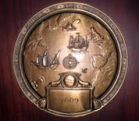
well done on the 2009 Blue Water Medal Brilliant. I saw the news on Lin Pardeys blog. I thought it was funny that she did not recoginse you in your shore cloths! keep up the sailing and the writing
Adrian Moss
Chichester harbour
adrian@adrianmoss.org
lovely to hear from you at long last,as usual beautifully described.long continue.greetings from the north west of england.
david g.
Post a Comment